27 April 2025
On 10 April 2025, the ACT Legislative Assembly passed a motion put by Jo Clay, the Greens member for the seat of Ginninderra, calling on the ACT Government to set an urban growth boundary this term of government; consider the need to preserve land of environmental value, the future land needs of the Territory, the need to protect the Western Edge, and the need to preserve agricultural land use as established in the Eastern Broadacre study; conduct public consultation in accordance with the Planning Act 2023 (ACT) to establish the urban growth boundary; release an amendment to the Territory Plan to establish the urban growth boundary by June 2027; and to publish half-yearly statements on progress, beginning in the first sittings of 2026.
The ACT Government has not yet made any public statements about this motion, so it will be interesting to see how it plans to respond.
As an urban and regional planner with over 50 years’ experience, I have long held the view that urban development has a rapacious appetite for land (and water). And that’s not always good for the environment. Or for people. Placing a limit on Canberra’s outward and upward urban growth has considerable merit. Provided it is done with some careful longer-term planning.
The proposition of establishing a firm urban growth boundary raises some interesting questions: Why are we doing this? What are we hoping to achieve? And more importantly, how do we plan for the next 500,000 people, or more (if we want the city to continue growing)?
It should be noted however, that other cities such as Sydney and Melbourne have also tried to set outward urban growth limits in the past, but they have never held much sway against urban development’s ‘rapacious appetite for land’.
In answering those questions, I hasten to point out that there are already some significant limitations on Canberra’s outward urban development.
First, the ACT/NSW border. While there may be some relatively small areas suitable for urban development within the ACT, the only way in which additional new towns of about 90,000 to 100,000 people can be added is to go to the north of Belconnen and Gungahlin, which necessitates going over the border. Any such expansion will necessitate the acquisition of land from NSW by the Commonwealth. The ACT cannot take that land from NSW in its own right. It can only occur with the agreement of the Commonwealth. And in the light of the High Court of Australia’s most recent ruling about s.51(xxxi) of the Constitution (Commonwealth v Yunupingu delivered on 12 March 2025), I can’t see the Commonwealth avoiding the landholder’s rights to compensation ‘on just terms’.
Second, the metropolitan transport task. When Peter Harrison (Canberra’s first Chief Planner) was tasked with planning the expansion of Canberra beyond the Griffin plan in the 1960s to cater for a city of 250,000 people and then 500,000 well before the end of the 20th century, he applied two key principles from the Griffin plan: fit the city into the landscape and ensure there is an in-built public transport spine. Peter Harrison also gave some thought to city structure. He appreciated that it was not possible for Canberra to keep growing outwards like a doughnut with one dominant CBD in the middle like Sydney, Melbourne or Brisbane. The topography simply does not allow for that to happen in an orderly manner. Rather, Peter Harrison designed a linear arrangement of new towns with employment centres in each to generate reverse loading on the central public transport spine. That’s why the city has a linear ‘Y’ shape with growth contained within the surrounding hills and ridges. And he also ensured that the arterial road network connecting the towns were located on the periphery of the new towns and did not bisect them.
Third, the natural topography. The city’s overall structure was determined by the hills, reserves and ridges that have since been classified as the National Capital Open Space System (NCOSS) in the 1984 Metropolitan Canberra Policy Plan & Development Plan by the former NCDC. The NCOSS is still classified in the current National Capital Plan prepared and maintained by the National Capital Authority (see Figures 1 and 2 below). It covers over 70 percent of the ACT and includes the hills, ridges and buffers between urban areas, the Molonglo and Murrumbidgee River Corridors, Lake Burley Griffin, and extensive areas of mountains and bushland to the south of the city, including the Namadgi National Park and Tidbinbilla Nature Reserve. Most of this land is unsuitable for urban development, as most of it is catchment for Canberra’s water supply. The NCOSS defines the natural setting of Canberra, it has already played a significant role in shaping Canberra’s development, and it will continue to do so.
The current National Capital Plan prescribes the following Principle for the planning and management of NCOSS:
“The NCOSS is required to protect the nationally significant open-space framework, visual backdrop and landscape setting for the National Capital. NCOSS will blend city and country in a way that symbolises the character of the National Capital and provides a balanced range of uses which reinforces the natural, cultural, scenic and recreational values of the ACT.”
The NCOSS serves four different functions, each with its own specific policies for land use planning in those areas:
• Symbolic spaces that embody the national importance of the landscape in a diverse cultural environment and the intrinsic connection between the physical setting and continuing legacy of Canberra as a planned city.
• Conservation spaces are those that protect, conserve and enhance the natural environment, the heritage and cultural values of the ACT, and which provide for ecological connectivity.
• Living spaces are those that provide direct health and wellbeing benefits to the broad range of users in close proximity to urban areas and which afford appropriate movement to people, fauna and flora.
• Linking spaces that physically join and visually unite the city to its immediate setting and to the region. The values contained in these spaces include the spatial and temporal continuity provided to the setting of the National Capital.
Together these open spaces constitute a system which protects the environmental quality of Canberra’s present and future water catchments, river systems, and important ecological and heritage areas from the increasing pressure of Canberra’s growth. While each part has its own land use and character, they are all interrelated as parts of a total system. It is important therefore that the system is planned, developed and managed on an integrated basis.
Some parts of NCOSS fall within the Designated Areas of the National Capital Plan that come under the control the National Capital Authority, while other parts of the NCOSS come under the control of the Territory through the Territory Plan. Co-operation between the Commonwealth and Territory governments is vital if the city’s growth is going to continue meeting its dual purpose of being both, Australia’s national capital as well as a place for its residents to live.
The value we place on the hills, ridges and open spaces have made this city one of the most amenable and liveable cities in the world.
The recent tussle over whether to retain Bluett’s Block for its conservation values brings these issues into stark relief.
Fourth, water supply. Australia is the driest continent on Earth, and with the increasing impacts of climate change we will be living in a hotter and dryer climate. The ACT is wholly situated within the Murrumbidgee River Catchment, which feeds into the Murray–Darling River system–Australia’s biggest river system, and also one of the world’s driest. While some significant structural and behavioural changes were made to increase Canberra’s water supply system following the Millenium drought, the likelihood of further severe droughts is increasing. So far, we have not had to re-introduce the water restrictions that were so necessary to cope with the Millenium drought, but with increasing population and outward sprawl, there are physical limits to which the system can continue to be expanded without further up-front costs. Further investigations and cost-benefit analyses are necessary.
Fifth, sewerage and waste-water treatment. Canberra is Australia’s largest inland city, and its sewerage must be treated to the highest standards because it has to be returned to the Murrumbidgee River. It is used downstream as potable drinking water and for irrigation for food crops. The Lower Molonglo Water Quality Control Centre (LMWQCC) near the mouth of the Molonglo River was originally built in the 1970s for a population of about 270,000 people. It was expanded and upgraded in 1992 and again in 2009-10 and is capable of serving a population of one million people. However, with the increasing impacts of climate change, we need to think about whether potable water should continue being used in the sewerage treatment system and how the system can cope with greater use of recycled water rather than continuing to discharge it into the Murrumbidgee River. The impacts that may have in the overall Murray-Darling Basin need to be carefully considered because discharges from the LMWQCC play a crucial role in the River’s ecosystem during severe droughts. It may also be necessary to consider building smaller treatment plants in other locations, especially if the sewerage system in new development areas are unable to be connected to the LMWQCC. Further investigations and cost-benefit analyses are necessary.
We should also learn a few lessons from Canberra’ planning history.
While the new towns were built and the trunk 333 bus routes suited Canberra during its early growing years, the Commonwealth never invested in the central fixed rail public transport spine before it handed self-government to the Territory in 1989. Since self-government, we have chosen a very light rail system that is a ‘toy train’ that is not up to the metropolitan transport task for a city that is likely to grow to a million people in the longer term. It is already often full in the morning and evening peaks. Another carriage can be added, but all the current platforms will need to be extended or reconfigured and that comes at a cost.
Canberra’s development has also departed from the linear ‘Y’ shape by allowing the Canberra Airport to become a town centre with activities that have nothing to do with its operation as an airport, significantly detracting from the development of the town centres in Tuggeranong and Gungahlin as well as Civic. Similarly, the development of Molonglo to the west did not include a town centre, and that is only belatedly being added. These east-west developments have significantly distorted the city’s ‘Y’ linear frame and have added to the complexity of the metropolitan transport task. These issues are not insoluble, but they come at a cost.
Each of the five factors discussed above will play a significant role in defining the limits of Canberra’s future urban growth and they need to be factored into any discussion about how we plan for the next 500,000 people, or more (if we think the city can cope with a million people).
We can and should increase density, but much of what we have done to date is far from ideal in terms of good urban design and pedestrian in scale. Much of the development of high-rise residential apartment blocks in Civic, Belconnen and Gungahlin and along the tram line on Northbourne Ave has been driven by maximum possible yield (and profit) at the expense of good urban design and amenity. Much the same can be said for the haphazard way residential density is being increased within our existing residential areas – poorly designed and oriented and driven by maximum yield rather than providing a wider range of housing options for changing demographics, household compositions and affordability with good access to public transport, employment, education and health and other facilities and services. Increasing residential densities in the existing urban fabric should not be at the expense of existing open spaces and amenity.
What is required is a sound understanding of the city’s physical and natural limits and a well-thought-out long-term strategic plan. We need to weigh up the different options and their relative costs and benefits, not only economically, but also environmentally and socially. Otherwise, we are likely to continue making the wrong decisions. And we should stick to the plan over time. Canberra had a good long-term plan once, but we didn’t stick to it. And that’s caused significant distortions to the city’s efficiency and impact on the environment. Our overall environmental footprint is large, some would argue it is already too large.
And we should also be talking to the Traditional Owners of the ACT and surrounds. As they never ceded their sovereignty, and we failed to treat with them when the site was selected for the national capital in 1909 and when self-government was granted to the ACT in 1989. And that must include all three groups with connections to the ACT and surrounds, the Ngunnawal, the Ngambri (Kamberri) and the Ngargu/Ngarigu. They lived here for thousands of years before us, and they know how we can live more sustainably within our environmental limits.
About the Author
Dr Ed Wensing began his planning career by participating in the ‘Gungahlin Think-In’ in the early 1970s before joining the former National Capital Development Commission (NCDC) in 1972. Ed worked his way up the ranks of the NCDC to become a senior town planner before furthering his career back in the Commonwealth in housing and urban policy roles before becoming PIA’s inaugural National Policy Director in the mid-1990s. Ed is currently Associate and Special Adviser with SGS Economics and Planning, a Research Fellow at the City Future Research Centre at UNSW and an Honorary Research Fellow at the Centre for Indigenous Policy Research at ANU.
Figure 1: General Policy Plan – Australian Capital Territory
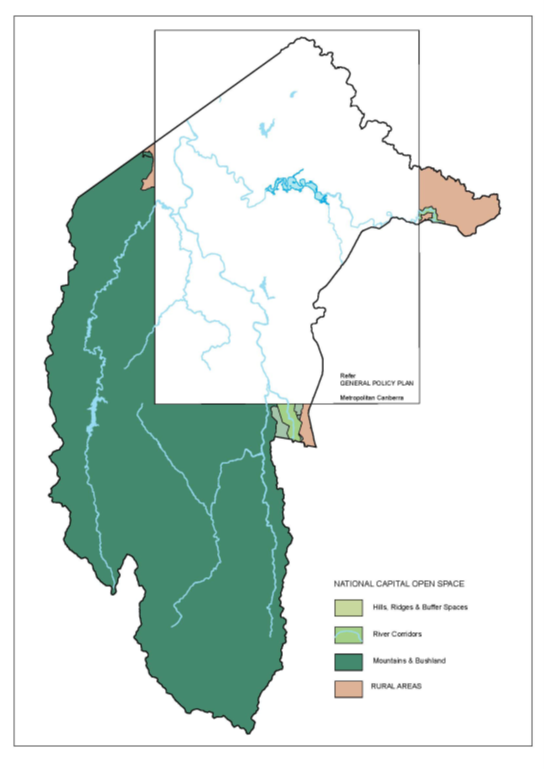
Source: National Capital Plan. Compilation date: 15 February 2025.
Figure 2: General Policy Plan – Metropolitan Canberra
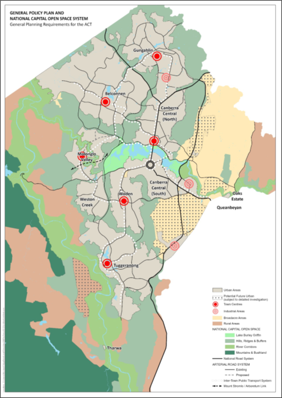
Source: National Capital Plan. Compilation date: 15 February 2025.